What is a metadata statement?
Metadata statements detail information about data, including:
- When data was collected
- How data was collected
- Why data was collected
- Any limitations on its use, and
- How often data is updated.
Metadata statements must be provided to SEED by the agency, custodian or manager of each dataset.
Need to publish your metadata statements to SEED? Visit How to publish metadata and data quality statements.
What metadata standards does SEED follow?
SEED follows the ANZLIC metadata standards for spatial datasets. This standard defines the minimum and optimal set of information collected for each dataset.
Following a set of data standards makes it easy for the data to be compared to other maps and records.
How to access metadata statements
Metadata statements may be available in HTML, PDF, JSON or XML format.
You can access metadata statements in several ways.
- Using the ‘Download metadata’ options on the SEED Dataset View page.

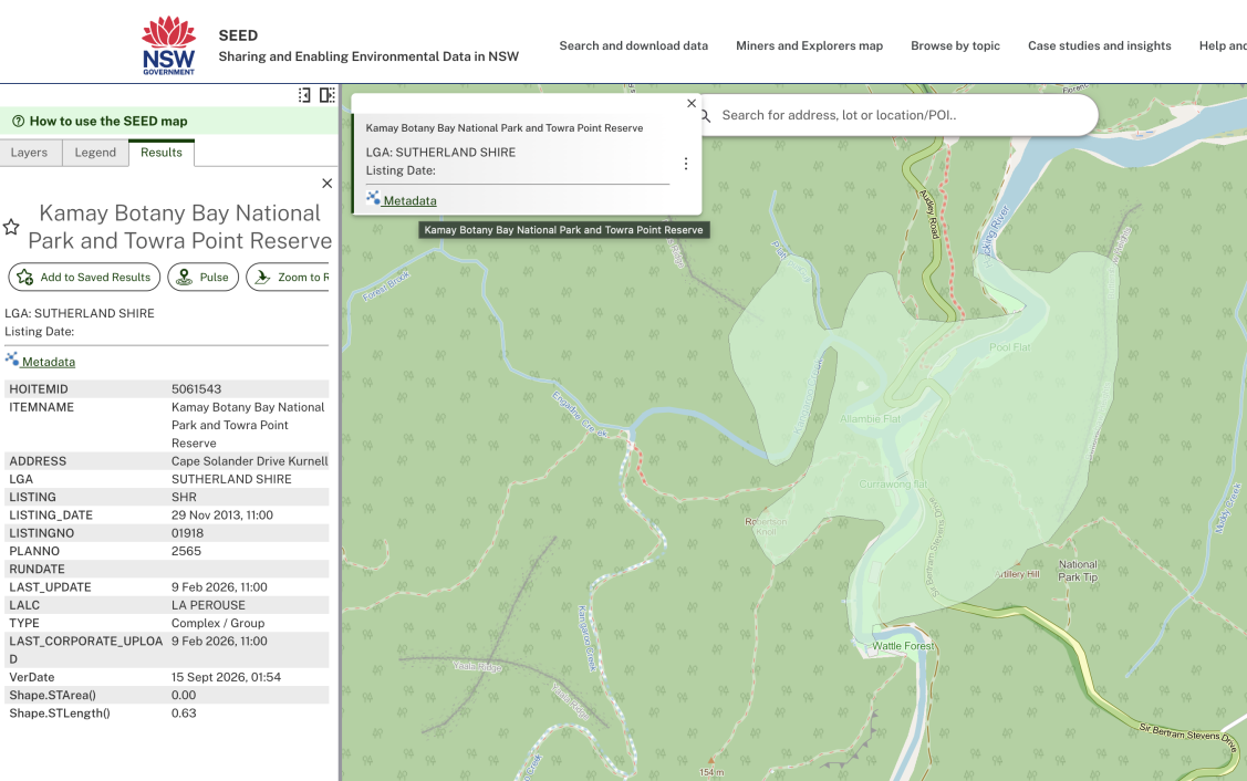
From the SEED map, using the 'Metadata' link when you select a particular map feature.
What metadata does SEED collect?
ANZLIC defines the metadata elements that can be documented. Some elements are optional for SEED datasets. Each dataset shows its mandatory metadata elements.
Title | A concise and descriptive heading that provides information about the content or focus of the dataset. The title should have the “what”, “where” and “when” information relevant to the business use of the dataset. It serves as a brief identifier to help users understand the nature and scope of the data, facilitating easy recognition and retrieval of specific information within the dataset. |
Alternative title | Refers to an additional or substitute name given to a dataset, providing an alternative way to identify or reference the information contained within the dataset. |
Contact | A free-text metadata element of the details of the organisation(s) responsible for the establishment, maintenance and distribution of the dataset. |
Language | The language in which this dataset is presented in. |
Edition | A specific version/edition of the data released at a particular time, subject to updates for accuracy and relevance. |
Parent | A "Parent" dataset refers to a primary dataset within a collection composed of multiple datasets. It serves as the overarching dataset from which other constituent datasets are derived from or are part of. |
Geographic Bounding Box | The geographic bounding box contains values of the approximate longitudes and latitudes that bound the dataset. |
Presentation form | Information about the events or the source data used in constructing the data specified by the scope or lack of knowledge about lineage. |
Publication type | Indicates the specific category or format of the dataset. It provides information necessary for citation purposes and typically includes descriptors such as Annual Report, Checklist, Corporate Plan, Fact Sheet, Media Release, Policy Document, or Research Paper. This classification helps organise and identify the nature of non-geospatial datasets. |
Description | A concise overview detailing the content, structure, and key attributes of the dataset. |
Purpose | A short free-text summary of the intentions or aims with which the dataset was created. |
Field of research | The Australian and New Zealand Standard Research Classification (ANZSRC), 2008 defined field or fields of research relevant to the dataset. |
Geospatial topic | A high-level categorisation that facilitates grouping and keyword-based searches for relevant spatial information. Helps users identify and navigate datasets based on geographic themes. |
Status | Indication of the current condition or state of the resource. It provides information on whether the data collection or resource is completed, continually being updated, or in any other relevant state that describes its current status. |
Organisation | Refers to the entity, institution, or agency responsible for generating or managing the dataset. |
Visibility | Refers to the selection of whether the dataset should be accessible to the public (Public) or restricted to authorised users (Private). |
Date of asset creation | The specific date on which the relevant environmental information or dataset was initially acquired or generated. This date is crucial for tracking the temporal aspect of the dataset and is distinct from other date-related metadata fields, such as the "Created" date for attached resources, providing a clear reference point for the dataset's origination. |
Date of asset revision | The specific date on which changes were made to the dataset. This date indicates when revisions, updates, or amendments were applied to the data, providing users with information about the most recent changes made to the data. |
Frequency of change | Indication of how often updates or additions occur after the initial creation, specifying intervals such as Daily, Weekly, or Never. |
Date of asset publication | The date that the dataset was first published. |
Date of next update | Scheduled revision date for the dataset. |
Keywords | Refers to specific terms, words, or phrases that are commonly used to describe and categorise the subject content of the data. These keywords help users quickly identify and retrieve relevant information from the dataset, facilitating efficient search and analysis processes related to environmental topics. |
Tags | Uncontrolled terms in metadata, offering flexibility to describe resources with terms outside controlled vocabularies like Keywords or Field of Research. |
Metadata date | The specific date on which the metadata record associated with the dataset was initially completed or substantially finalised. It serves as a reference point indicating when the metadata information was first prepared, distinct from the date of any subsequent updates or modifications to the metadata. |
Temporal coverage from | The start date of a period during which data within an environmental dataset was collected. It provides information about the temporal extent of the dataset's content. |
Temporal coverage to | The end date of a period during which data within an environmental dataset was collected or is applicable. It provides information about the temporal extent of the dataset's content. |
License | The licence type applied to assure the protection of privacy or intellectual property, and any special restrictions or limitations or warnings on using the dataset eg CC BY 4.0, 3rd party licence, internal agency use only. |
NSW place name | The NSW place name in which the dataset pertains to. |
Extent | The geographic and temporal boundaries that define the coverage of the data. It provides essential details about the spatial and temporal scope of the dataset, offering a basic description of the area and time period covered by the data. |
South latitude | The south bounding latitude coordinate of the dataset provided in decimal degrees to create the dataset extent. |
West longitude | The west bounding latitude coordinate of the dataset provided in decimal degrees to create the dataset extent. |
North latitude | The north bounding latitude coordinate of the dataset provided in decimal degrees to create the dataset extent. |
East longitude | The east bounding latitude coordinate of the dataset provided in decimal degrees to create the dataset extent. |
Datum | A geodetic datum is a global reference for precisely representing the position of locations on Earth. Provided as a standard datum specification e.g. GDA94 or GDA2020. |
Lineage | A record detailing the data's origin, including source data description, scale, media type, and processing steps. Provides transparency on data history, methodology, and transformation. |
Supplemental information | Additional details or context provided alongside the dataset, enhancing the understanding and usefulness of the data. |